18.3.11.040 Establishment of Water Resource Protection Zones
A Water Resource Protection Zone is hereby established adjacent to and including all Water Resources to protect their integrity, function, and value. The boundaries of the following Water Resource Protection Zones shall be established by an on-site survey based upon the following standards.
A. Stream Bank Protection Zones. The following types of Stream Bank Protection Zones are hereby established to protect streams and their associated riparian resources. The approximate locations of streams are identified on the Water Resources map.
1. Riparian Corridor. For streams classified as Riparian Corridor fish-bearing streams with an annual average stream flow less than 1,000 cubic feet per second and on the Water Resources map, the Stream Bank Protection Zone shall include the stream, plus a riparian buffer consisting of all lands within 50 feet upland from the top of bank as illustrated in Figure 18.3.11.040.A.1.
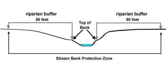
Figure 18.3.11.040.A.1. Stream Bank Protection Zone for Riparian Corridor Streams
2. Local Streams. For streams classified as non-fish-bearing Local Streams and on the Water Resources map, the Stream Bank Protection Zone shall include the stream, plus a riparian buffer consisting of all lands 40 feet from the centerline of the stream as illustrated in Figure 18.3.11.040.A.2.
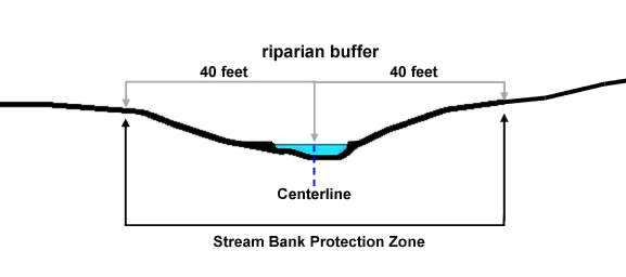
Figure 18.3.11.040.A.2. Stream Bank Protection Zone for Local Streams
3. Intermittent and Ephemeral Streams. For streams classified as Intermittent and Ephemeral Streams on the Water Resource Protection Zones map, the Stream Bank Protection Zone shall include the stream, plus a riparian buffer consisting of all lands within 30 feet from the centerline of the stream as illustrated in Figure 18.3.11.040.A.3.
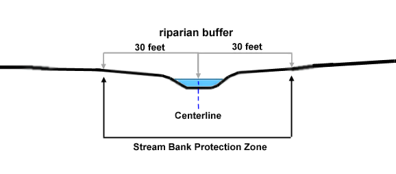
Figure 18.3.11.040.A.3. Stream Bank Protection Zone for Intermittent and Ephemeral Streams
4. Significant Wetland Presence. Where a Stream Bank Protection Zone includes all or part of a significant wetland as identified on official maps adopted by the City, the distance to the Stream Bank Protection Zone boundary shall be measured from, and include, the upland edge of the wetland.
5. Determination of Protection Zone. The measurement of the Stream Bank Protection Zones shall be a horizontal distance from the top of bank or from the center line of the stream as specified above. For streams that were piped or relocated to a culvert prior to the effective date of this chapter, the Stream Bank Protection Zones shall be reduced to half of the required width or the width of any existing easement (e.g., drainage-way easement), whichever is greater.
B. Wetland Protection Zones. The following types of Wetland Protection Zones are hereby established to protect wetland resources. The approximate locations of Locally Significant Wetlands and Wetlands are identified on the Water Resources map. The precise boundary of a wetland and wetland buffer shall be established through conducting an on-site wetland delineation and survey based upon the following standards.
1. Locally Significant Wetlands. For wetlands classified as Locally Significant on the Water Resources map, the Wetland Protection Zone shall consist of all lands identified to have a wetland presence on the wetland delineation, plus a wetland buffer consisting of all lands within 50 feet of the upland-wetland edge as illustrated in Figure 18.3.11.040.B.1. A wetland delineation prepared by a qualified wetland specialist shall be submitted to the City that graphically represents the location of wetlands on a site plan map in accordance with subsection 18.3.11.100.A.3. An average buffer width of 50 feet may be utilized around the perimeter of a significant wetland upon submission of evidence and a detailed plan by a natural resources professional demonstrating that equal or better protection of the functions and values of the resource will be ensured, and that there will be an enhanced buffer treatment through the implementation and maintenance of a restoration and enhancement plan within the buffer area.
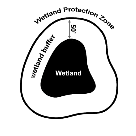
Figure 18.3.11.040.B.1. Wetland Protection Zone for Locally Significant Wetlands
2. Possible Wetlands. For wetlands not classified as Locally Significant on the Water Resources map, the Wetland Protection Zone shall consist of all lands identified to have a wetland presence on the wetland delineation, plus all lands within 20 feet of the upland-wetland edge as illustrated in Figure 18.3.11.040.B.2. Possible Wetlands includes all areas designated as such on the Water Resources map and any unmapped wetlands discovered on site. A wetland delineation prepared by a qualified wetland specialist shall be submitted to the City that graphically represents the location of wetlands on a site plan map in accordance with subsection 18.3.11.100.A.3. An average buffer width of 20 feet may be utilized around the perimeter of a possible wetland upon submission of evidence and a detailed plan by a natural resources professional demonstrating that equal or better protection of the functions and values of the resource will be ensured.
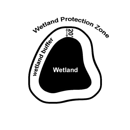
Figure 18.3.11.040.B.2. Wetland Protection Zone for Possible Wetlands
3. Determination of Protection Zone. The measurement of the Wetland Protection Zone shall be a horizontal distance from the upland-wetland edge as specified above.