18.3.10.040 Application Submission Requirements
The following information is required for a Physical Constraints Review Permit application, except where the Staff Advisor determines a submission requirement is not reasonably necessary in order to make a decision on the application:
A. Project name.
B. Vicinity map.
C. Scale (the scale shall be at least one inch equals 50 feet or larger) utilizing the largest scale that fits on 22-inch by 34-inch paper. Multiple plans or layers shall be prepared at the same scale, excluding detail drawings. The Staff Advisor may authorize different scales and plan sheet sizes for projects, provided the plans provide sufficient information to clearly identify and evaluate the application request.
D. North arrow.
E. Date.
F. Street names and locations of all existing and proposed streets within or on the boundary of the proposed development.
G. Lot layout with dimensions for all lot lines.
H. Location and use of all proposed and existing buildings, fences, and structures within the proposed development. Indicate which buildings are to remain and which are to be removed.
I. Location and size of all public utilities affected by the proposed development.
J. Location of drainage ways or public utility easements in and adjacent to the proposed development, and location of all other easements.
K. Topographic map of the site at a contour interval of not less than two feet nor greater than five feet. The topographic map shall also include a slope analysis, indicating buildable areas, as shown in Figure 18.3.10.040.K.
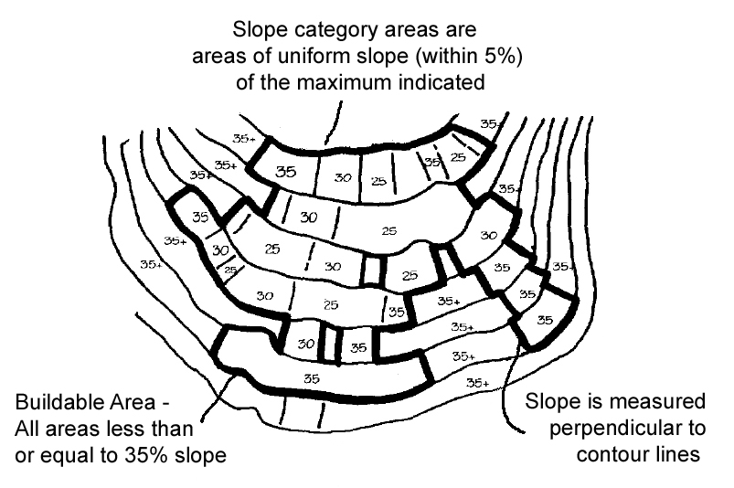
Figure 18.3.10.040.K. Slope Analysis
L. Location of all parking areas and spaces, ingress and egress on the site, and on-site circulation
M. Accurate locations of all existing natural features including, but not limited to, all trees as required in 18.3.10.090.D.1, including those of a caliper equal to or greater than six inches in diameter at breast height (DBH), native shrub masses with a diameter of ten feet or greater, natural drainage, swales, wetlands, ponds, springs, or creeks on the site, and outcroppings of rocks, boulders, etc. Natural features on adjacent properties potentially impacted by the proposed development shall also be included, such as trees with drip-lines extending across property lines. In forested areas, it is necessary to identify only those trees that will be affected or removed by the proposed development. Indicate any contemplated modifications to a natural feature, including trees, method of erosion control, water runoff control, and proposed tree protection for the development as required by this chapter.
N. Building envelopes for all existing and proposed new parcels that contain only buildable area, as defined by this chapter.
O. Location of all irrigation canals and major irrigation lines.
P. Location of all areas of land disturbance, including cuts, fills, driveways, building sites, and other construction areas. Indicate total area of disturbance, total percentage of project site proposed for disturbance, and maximum depths and heights of cuts and fill.
Q. Location for storage or disposal of all excess materials resulting from cuts associated with the proposed development.
R. Applicant name, firm preparing plans, person responsible for plan preparation, and plan preparation dates shall be indicated on all plans.
S. Proposed timeline for development based on estimated date of approval, including completion dates for specific tasks.
T. Additional plans and studies as required in sections 18.3.10.080, 18.3.10.090, 18.3.10.100 and 18.3.10.110 of this chapter. (Ord. 3158 § 3, amended, 09/18/2018)